Latest Videos
Published on Jan 7, 2016
A Channel 7 helicopter flies over the small town of Yarloop, after an out of control bushfire with record high winds devastated 95 homes and other constructions.
Published on Jan 7, 2016
Watch this video of the small town in our south-west as a bushfire hits. At the time of this video the neighbouring towns were under threat with high winds and 40 degree temps.
BAL Rating News
- The wait is over Bushfire BAL area map is now open to public.
- And new data shows nearly 12,000 buildings have been erected in high-risk areas such as Ellenbrook, Atwell and Wandi in the past three years.
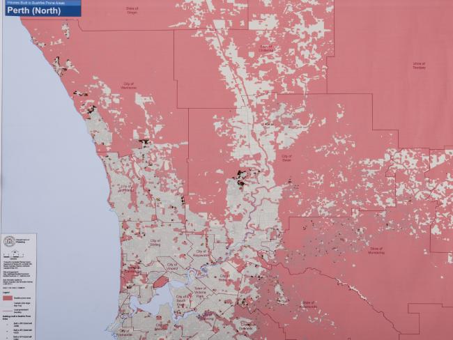
The Map of Bush Fire Prone Areas categorizes land that is within the deemed bushfire as designated by the West Australia government.
A Shared Responsibility
- 71 homes destroyed and a further 39 damaged. A report into the Perth Hills Bushfire.
- The Auditor General noted that dangers connected with major bushfires are increasing, including due to differences in land use due to urban sprawl, with housing estates extending into bushfire prone areas. He also committed that greater fuel levels are contributing to a greater than before level of risk.
The Review Committee noted agencies would check at the beginning of the fire season on fuel reduction plans high risk areas and prepare State level action and an agreed burning policy.
Under the Local Government Act 1995 local governments may state all or parts of their states to be bushfire prone area. A designated bushfire prone area is defined under the National Construction Code (formerly known as the Building Code of Australia) as land nominated as being subject, or possible to be subject to, bushfires. Under the Construction Code, areas chosen as bushfire prone are required to meet a set of requirements. These requirements can be met through complying with the Australian Standard AS3959-200926. AS3959-2009 prescribes construction standards for buildings founded on an (BAL) assessment of Bushfire Attack Levels linked to expectant radiant heat exposures.
The necessities of some construction in bushfire prone areas specified in AS3959-2009 aim to increase resistance to bushfire attack from radiant heat, burning embers, flame contact and mixtures of the three occurrences . Some appearing before the Special Inquiry were anxious that an announcement of a bushfire prone area would mean building standards would have universal application. This is false as the exact construction requirements depend on the bushfire attack level as determined an assessment.
This means that while a house could be in a bushfire prone area, the requirements will not inevitably apply except if the property has a certain BAL Rating.
The report lists 55 Recommendations are can be found in the link below.